
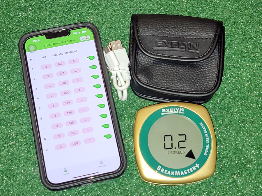
The BreakMaster+ is a green charting device now with Bluetooth and a cell phone app. The BreakMaster App allows golfers to chart greens and holes on any number of golf courses for absolute accuracy and convenience.
I own the previous version as well. The device reads the slope amount and slope direction where you place it on the green.
In fact, I used the original product to create green maps for my local course.
The BreakMaster+ with Bluetooth and cell phone app allows you to create green maps on your cell phone.
Rating: BreakMaster+ device: ★★★★ Why not 5 stars?
It’s very accurate and handy…but…. It doesn’t have the option to read in degrees or percentage of slope.
This isn’t a deal breaker for me as I always use degrees. However, even my cheap digital level has the option to measure in degrees and percentage of slope.
Software: ★★★ Why 3 stars?
It’s pretty good for new software. It needs more work. I’ve made recommendations and posted some below.
More photos below
What do you get in the box?
- BreakMaster+
- Carrying case
- USB charging cable
Note: The app is available at the Apple app store.
In fact, it’s a good idea to download the app and see if this is something you want to do. You can actually, begin to add Fairway and Green data or just Green data in the app to see if it’s for you.
The BreakMaster+ is set to go out of the box. There is no need to calibrate it for level.
I did charge mine for some time (they recommend 2 hours) after I took it out of the box.
Overview
The idea here is that you draw “fairways and / or greens” for the holes at your course. You can add water, sand, trees and shrubs, etc.
When you connect the BreakMaster+ with your iPhone via Bluetooth, you can measure break or slope and it shows up on the greens you sketch in the app.
It’s a handy and accurate device. The software can use some tweaks.
Help creating the green shapes
I like to use Google Earth Pro in top down view. Use this view as a reference to sketch the shape of greens, sand traps, water, etc.
You could zoom into your greens and print them off for reference.
Filling in the green or other data
You can use Google Earth Pro to measure from the tee you use to the front, middle and back of the green.
Adding carry distance to the front and back of traps, etc. is a good idea.
This can get very detailed if you are including Fairway and Green data.
I tried filling in one hole to start. I began with the green shape.
After that, added a sand trap and several rises around the green.
Filling in the green slope data requires using the BreakMaster+. You simply, connect your iPhone app to the device.
Then tell the app to measure. Touch the green you created in the app in the location where you have placed the BreakMaster+.
The break or slope amount appears in degrees with an arrow for direction.
Then repeat that feature to fill in as much slope / break data as you want to fit on the green.
Directions
There are directions built into the app. under settings. Look for “How to use it?”
Who is this for?
That depends upon where you play golf and maybe your computer skills.
In general terms, the BreakMaster+ and app gives everyone the ability to map fairways and greens at any golf course you play.
Obviously, you can’t hold up play while you are mapping things, but over time you can create as much detail as you can fit on the screen. They suggest adding detail over a number of rounds.
My take on the purchase
I have the previous version. It was the BreakMaster only and cost around $100 dollars.
The new version is $200. I had to think about the purchase for awhile.
Why? I needed to see there was a reason for me to buy this.
I’ve already made greens books for my local course. The other course I play at regularly has Strackaline yardage books and green maps.
So where does that take us. Well, I think this is going to help on other courses I play that “DO NOT” offer yardage books and green maps.
Things I’d like to see
I wish they would add or change several things.
- A text tool
- Need a function to add practice greens
- More colors
- A small black circle for previous hole location
- An UNDO button
- Dotted line and normal line option
- The device shuts off too fast. That needs to change.
Conclusion
I think this will be pretty handy for a lot of people…for others it will be tedious work.
The directions are fairly good. I’m NOT giving them an A+ on that. It took me a couple days to figure things out.
You can go back and edit after saving which is handy.
I would start out simple and add detail over time.
For me, there could be more tools and it could be easier to edit.
However, they set things up so it not easy to accidentally edit something and regret it. Which is a good.
There is no selection tool like there would be in software I’m used to.
You need to select the tool that you initially used in order to edit an existing feature you created.
Example: You want to move a tree around. I’d move it right away. If you edit after you save things, you need to go back in and select the tree tool and click on the existing tree to select it….then move it.
A dotted red box appears around the feature when it is selected.
All in all, I like the new system. It could be a bit more robust for editing.
It’s very accurate. I’d recommend it if you would like to create fairway and green maps.
Options
Currently, this app is only available for iPhones.
So… What if you don’t want to buy a new phone or don’t feel comfortable making the maps in the app.
- Buy a yardage book with green maps from Strackaline if they have one for your course. Note: They do not have a large selection of courses mapped for fairways AND greens.
- They only had one for the courses that I play in my area. So, I have one Strackaline book out of the 5 or 6 courses I might play.
- Make you own yardage and green books if you are good with a computer. This is what I initially did for my local course.
- So I have one Strackaline book and I made another book for a 2nd course myself. Now I have this device and app for other courses I may want to map.
- Measure slope and break using a digital level, BreakMaster for Golf Android app or the BreakMaster+. Then, purchase a yardage book or greens book and draw data points with a pencil.
(Note: A digital level or the BreakMaster for Golf Android app can measure slope in degrees or percent. The BreakMaster+ only measures in degrees.)
To compare options view our article on Strackaline Yardage and Green Maps along with our article on mapping your own greens using a computer.
Final Notes:
Keep in mind that most measurements will come from Google Maps Pro as far as yardages are concerned. You use the measuring tool in that app.
Using the BreakMaster+ and app you can add trees, sand, water, shrubs, etc. along with slope amount and slope direction.
Photos
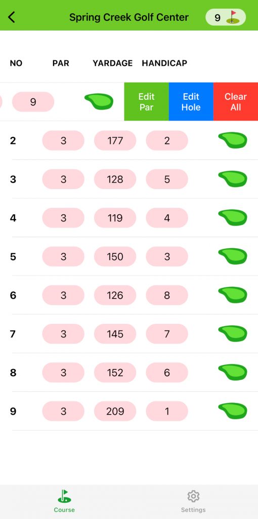
Note: The first thing I did was add the course, fill in the par, yardage and handicap, and then I drew green outlines and other features for each hole.
So, you start with a blank slate and fill everything in / draw shapes using your finger.
The first image below assumes you have done that and shows selecting “Edit Hole.“
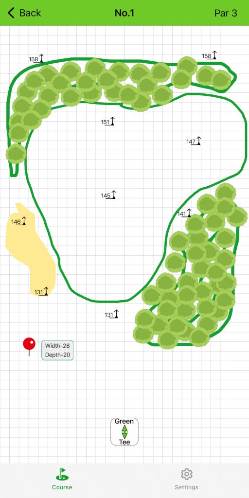
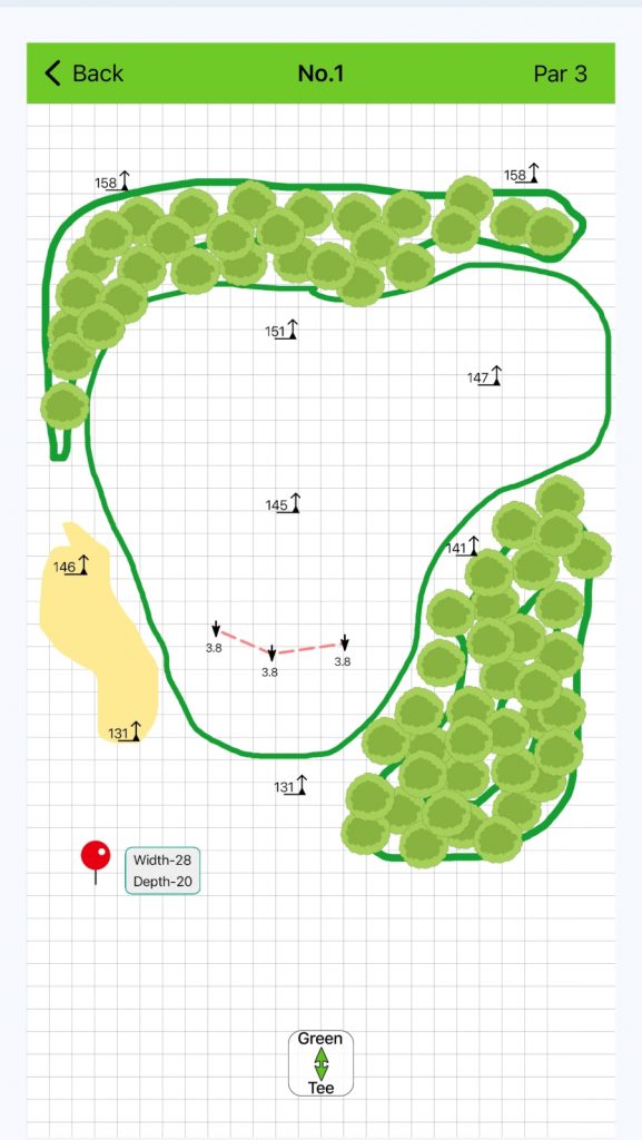
These maps are for Spring Creek Golf Center in Whitewater, WI which features championship greens and all par 3 holes. My layout is from the white tees.
You may notice odd break data on a couple images. I just created break / slope data for examples… However…
The last image is accurate for the 1st hole at my home course.
Swipe left and click edit hole
There is no option for text – I used shrubs for rise
The yardage measurements are from Google Earth Pro

I touched the screen there to insert the green dot.
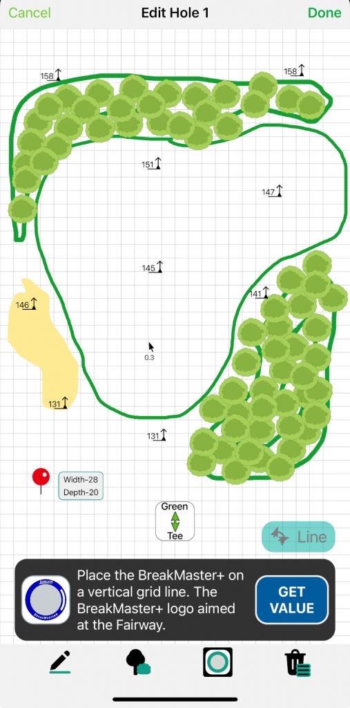
Slope Line Mode feature to create a ridge
or significant break feature in the green
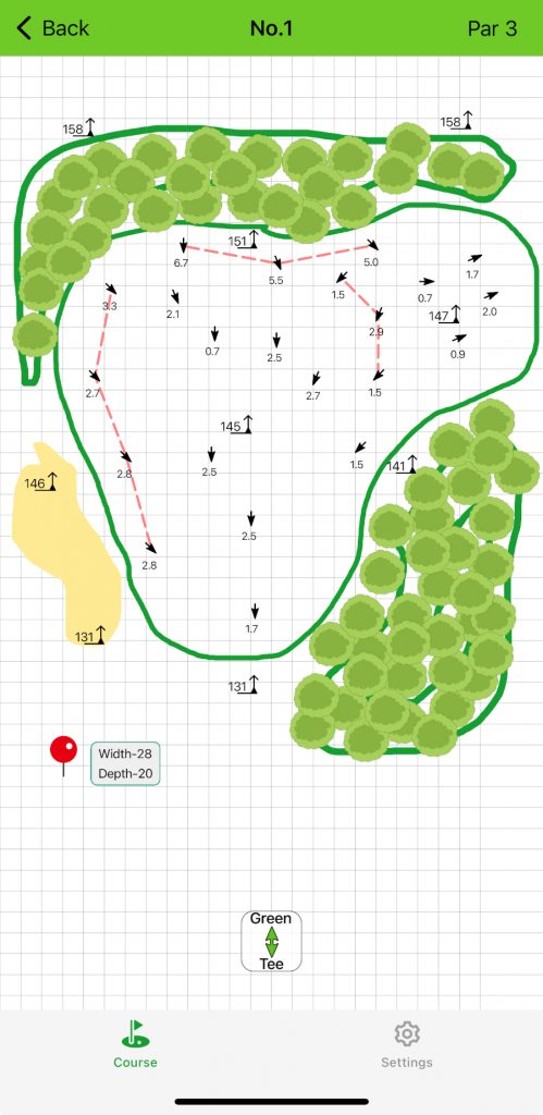
The dotted lines are significant ridges in the green
I really would prefer to add red, green and yellow areas
Those would represent stop, go and caution sections.