
The Strackaline App is the digital version of their awesome yardage books and green guides. This app gives you GPS distances, green maps and the course layout right on your phone. Let’s take a look.
I’ve been using this app for several weeks now. I give it a big thumbs up. ★★★★★
Just as an example, I purchased the printed yardage book with green maps for a local course.
The current price is $55 for the book.
I use it in advance to plan a round of golf. I haven’t used the booklet in play much.
Why is the app different?
It uses the GPS on your phone.
It shows you where you are on the hole. You can view the distance to the green for example.
I am just getting used to using my phone while playing.
I look at yardages or green options while I’m in the cart or thinking about my next shot.
It is handier and quicker than using a booklet.
You can switch between yardage and green views.
I’m not bad mouthing the yardage and green books. In fact, you get more information using the booklets.
Example: You get elevation numbers and green slope numbers in the booklets.
I was told by customer service that they are in the process of adding more detail to the app.
This is the SLOPE BOLD OPTION
What’s in the Strackaline App
You simply download the app.
I use the Android version.
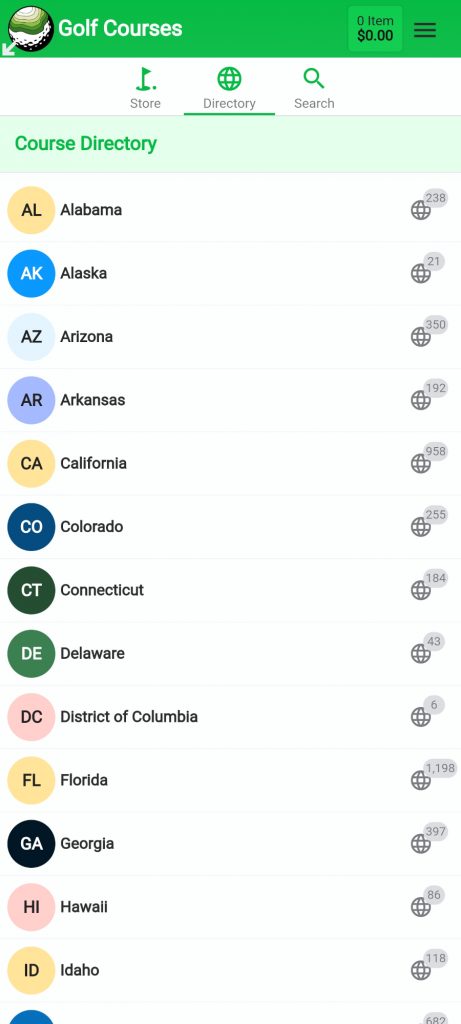
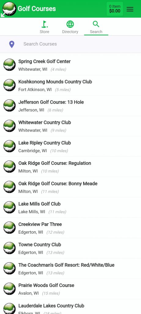
There is an option in the app to search for courses by state / country or you can use your location to view the courses starting with the ones nearest to you.
In my case by using location, the course where I’m a member was first on the list. All the others I play were in the top 20 or so.
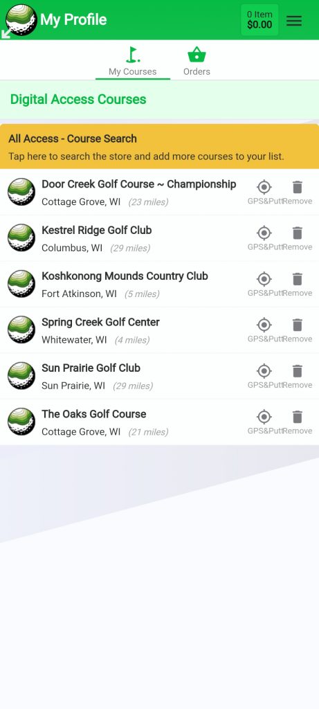
Once you view a course, it appears under “My Courses.” That means it’s readily available and you don’t have to search for it again.
That would be the opening screen. In other words, “My Courses.”
Once you select the course you want to play, the second screen gives you the following options.
- The Book – if you want to purchase the book
- The App – which is the default view
- The Pin Sheet – these are available on a really limited basis
- They would be available at tournaments for example
The course you select appears and you see generic “pin sheets” for every hole. This really is a visual representation of the greens for the holes on the course you selected.
The other two options are “Range” or yardage book and “Green” which is the green guide / map option.
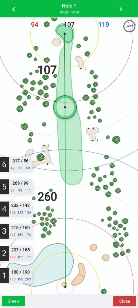
Strackaline App – Range,
You can change to the correct tee location by moving the slider with your finger.
Doing so gives you yardages from that tee.
Example: On a par 3, the distance to the middle of the green from the tee.
You also get the distance to front, middle and back of the green.
The app displays trees, sand traps, water, etc.
On a par 4 or par 5, you can adjust the landing zone to a distance you hit your driver or to where you may want to lay up for example.
You can do that by using your finger to move the layup slider.
As you physically move around the course, your location is represented as a blue circle on the screen.
Your layup or shot location choice is a green circle.
Here is an example?
My good layup yardage is around 100 yards out.
I know my drives max out around 220 yards from the old guy tees. So, I position the layup slider to 220 yards out from the tee.
Then the distance from there to the middle of the green appears or to wherever I move the pin location.
On the first hole at my local course, that just happens to be a perfect layup or 100 yards out.
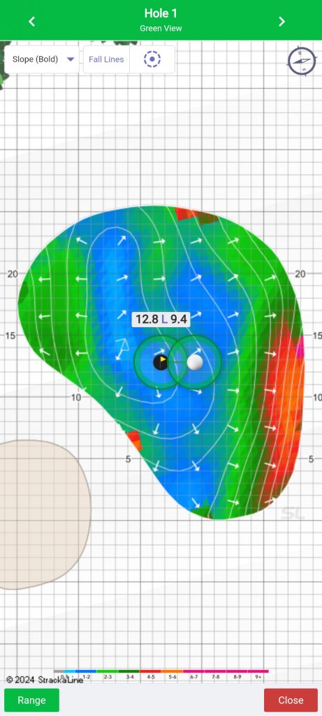
Strackaline App – Green
You see your preferred “green view” (see list below), the hole, a golf ball and size of the green in 5 yard increments.
So for example, I prefer a “heat map.”
In other words, blue color is a flat location, green is ok and red is really sloped.
There are also break direction or slope arrows on the heat map.
So what’s up with the hole and golf ball icons being displayed?
You move the hole location and ball location with your finger.
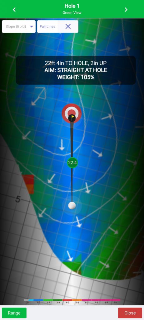
It’s green reading app also!!!
In the image below, I just chose a putt on hole #1. Then I selected the green reading option.
Here is the result in a notification the pops up on the screen.
22ft 4in to hole, 2in UP, AIM STRAIGHT AT HOLE, WEIGHT: 105%
So, it’s going to be a straight putt and is up hill requiring a little more pace.
Other Green map / guide options are:
- Simple arrows
- Elevation
- Slope
- Slope (bold)
- Slope (ice)
- HiLo
I prefer the Slope Bold that provides a heat map of the green and arrows for slope.
Conclusion
Let’s talk about cost.
The printed yardage books with green maps are $55 dollars each.
The Strackaline App is $99 dollars a year.
I have 6 courses selected. So let’s do the math.
I could pay $330 for those 6 booklets and $55 for each additional course… or pay $99 a year and have access to all available courses in the world and any upgrades.
My feeling it that it’s worth the $99 a year and the app is easier to use.
However, the yardage books and green maps currently give you more information. This might be something more appropriate for a caddy and player to use in a tournament.
Important: You need to use the printed yardage / green books to be “within the rules of golf.”
I’m don’t like to fumble around with yardage books while I’m playing. The App is just handy.
For the average golfer practicing, the app is my choice.
In fact, the first time I used it my partner started asking me what my app said for distance to hazards, etc.
Here is another handy option. The Strackaline App can be used as a planner prior to playing a course for the first time or to review a course layout.
I like the booklets and the app. The app is something I actually use. That’s the key.
More Photos
Note: Not all courses have lidar scanned green maps.
Of the 6 courses that I play, 5 of the 6 have yardage books and greens guides.
Some courses just have yardage books in digital format and no greens guides.
What I did was check to the print booklets first. The options for print booklets will indicate if they have yardage books and green guides.
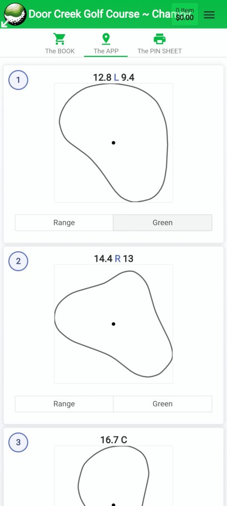
Pin Sheets appear for every hole
You touch range for the yardage book
or green for the greens guide
With regard to these pin sheets. Most courses do not offer day of play pin sheets. The most common view is middle of the green which I believe is the default.
The first number is distance to the front of the green and the second number is distance to the closest side.
You really just use the Range and Green features for each hole.
This opening course page let’s you select the hole you want to view by scrolling up and down.